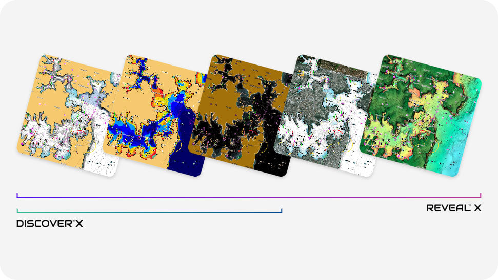
The X Generation of Charts
Compatible with B&G® Zeus® S
Compatible with B&G® Zeus® S

Compatible with B&G® Zeus® S
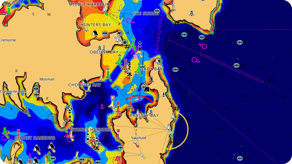
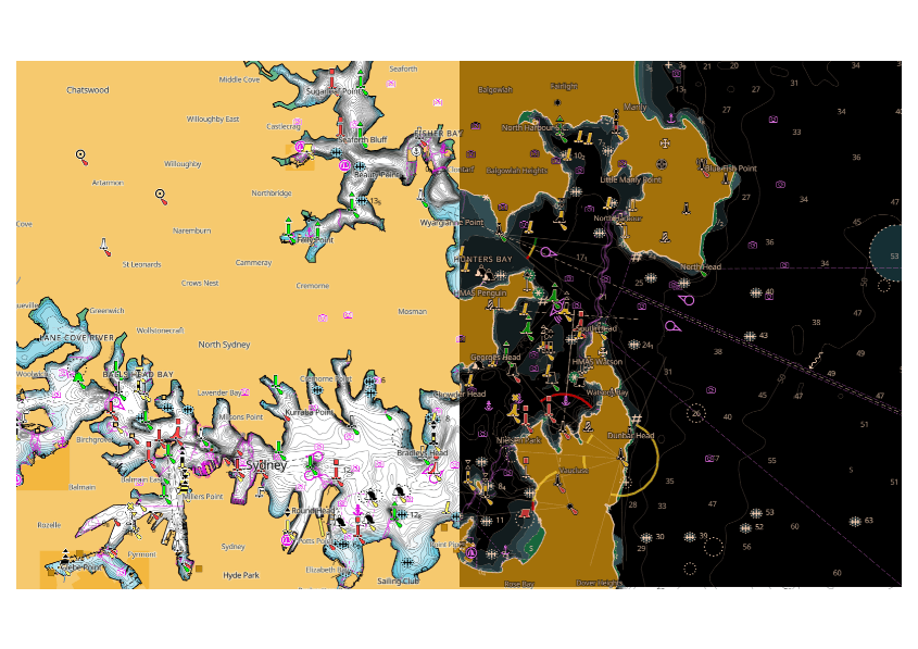
Always have the latest chart data at your fingertips with the C-MAP® X range. With an attractive display ensuring a clear, uncluttered view at all zoom levels and the most detailed High-Res Bathymetry, as well as best-in-class Day & Night modes.
Rich features include Tides & Currents and subscription-free Autorouting, and all chart purchases include 12 months free online updates.
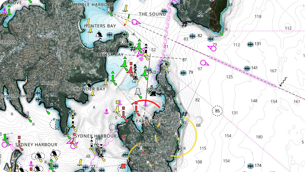
Upgrade to REVEAL™ X to unlock additional layers including Satellite Overlay.
Clean, uncluttered chart presentation, with full-featured vector data and rich features
The best C-MAP® contour data, which all-new, intuitive Map Inspector tool
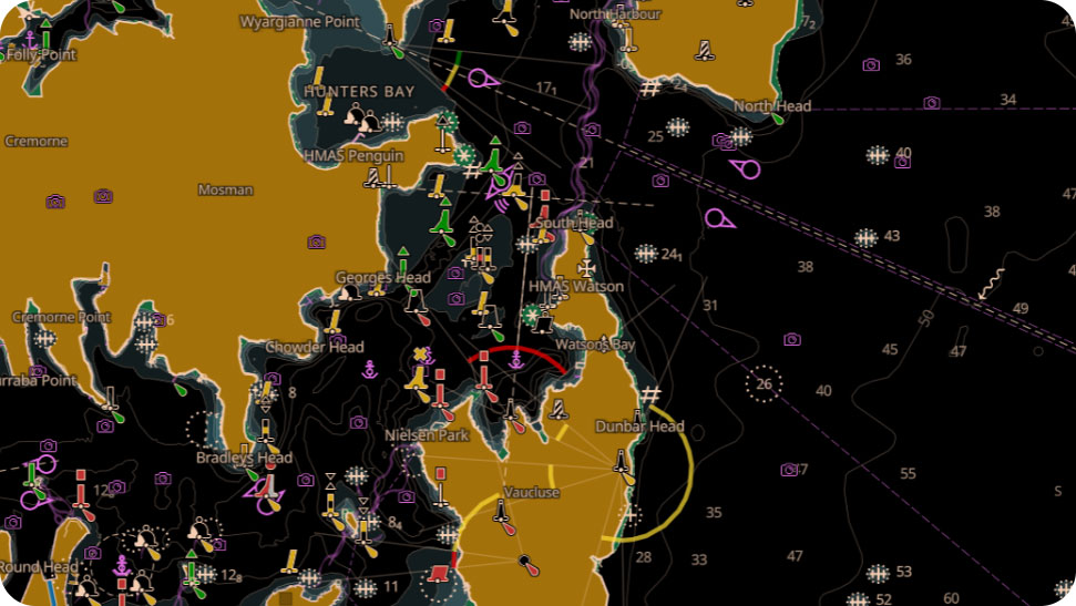
New Best-in-Class Day & Night Modes ensure best visibility in all light and weather conditions
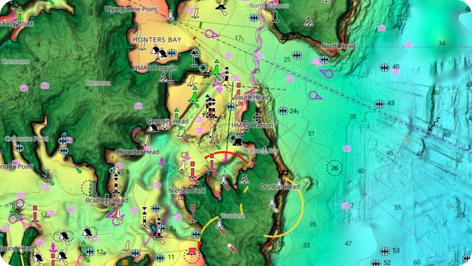
Maximise your situational awareness with a bird’s-eye view* only with REVEAL™ X
Get hassle-free software updates across your Zeus® S, App and Web.
Bring the world around you to life like never before, with photo-realistic views of the seafloor * only with REVEAL™ X
Clean, uncluttered chart presentation, with full-featured vector data and rich features
The best C-MAP® contour data, which all-new, intuitive Map Inspector tool
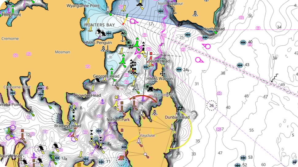
New Best-in-Class Day & Night Modes ensure best visibility in all light and weather conditions
Maximise your situational awareness with a bird’s-eye view* only with REVEAL™ X
Get hassle-free software updates across your Zeus® S, App and Web.
Bring the world around you to life like never before, with photo-realistic views of the seafloor * only with REVEAL™ X
![]()
Upgrade your day on the water. Experience the next level of navigation with REVEAL™ X. Includes all the rich data and features in DISCOVER™ X, plus additional layers to enrich your time on the water.
Satellite imagery gives information about the surroundings when you find yourself in an unfamiliar place. Stay safer on the water by maximizing your situational awareness.
Satellite imagery gives information about the surroundings when you find yourself in an unfamiliar place. Stay safer on the water by maximizing your situational awareness.
Bring the world around you to life, with 3D rendered underwater elevation – including areas of Ultra-High-Res imagery.
Bring the world around you to life, with 3D rendered underwater elevation – including areas of Ultra-High-Res imagery.
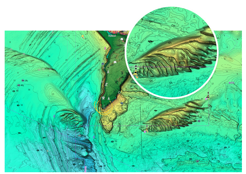
Big fish ambush little fish in submerged vegetation. Turn on the Vegetation layer to show the location, shape and depth of grass flats, deep weedlines, isolated patches and more**.
Big fish ambush little fish in submerged vegetation. Turn on the Vegetation layer to show the location, shape and depth of grass flats, deep weedlines, isolated patches and more**.
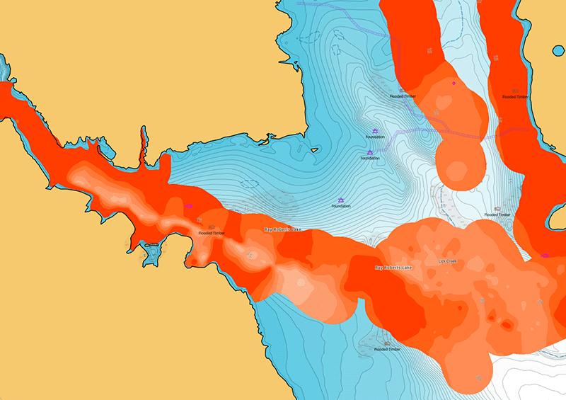
Fish love hard bottoms. They feed on them, breed on them, follow their edges like roads. The new bottom hardness layer shows the location, shape and depth of hard-bottom areas**.
**Vegetation and Bottom Hardness layers not available in all locations.
Fish love hard bottoms. They feed on them, breed on them, follow their edges like roads. The new bottom hardness layer shows the location, shape and depth of hard-bottom areas**.
**Vegetation and Bottom Hardness layer not available in all locations.
![]()
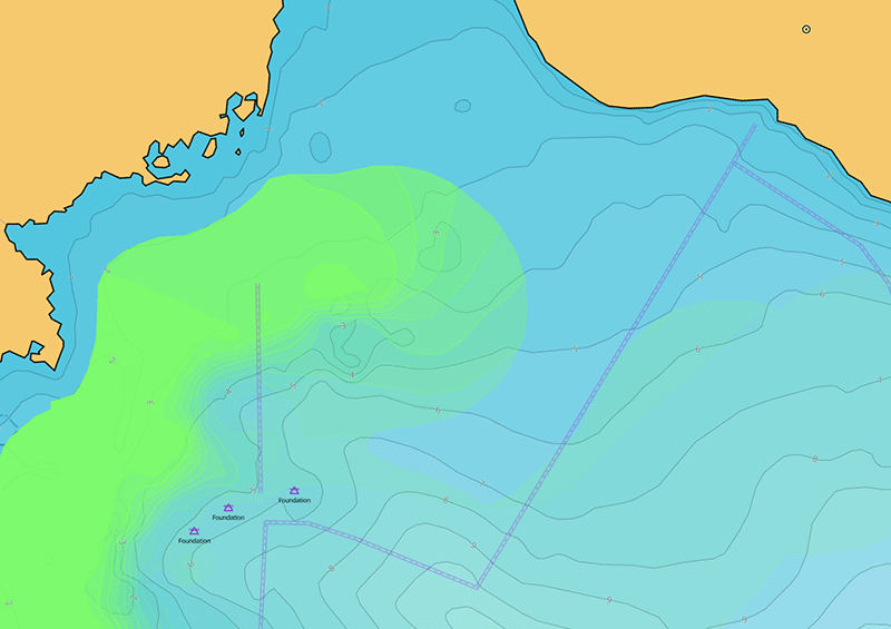
Identify shallow areas, drop offs, ledges, holes or humps. Includes the very best of C-MAP® HRB data, with integrated Genesis® social map data.
![]()
Allows you to set a safety depth or create your own shading and level-up your fishing – see things your way.
![]()
Show projections of water level and directions of tides to help plan your day out, whether cruising or fishing.
![]()
Docking in an unfamiliar port is no problem when you have precise layouts of thousands of marinas, including slip spaces, restricted areas and other valuable navigation information.
![]()
Unprecedented level of detail. Approach any harbor and inlet with confidence. The perfect partner at the end of a long cruise or an exciting day of fishing.
![]()
Automatically plot the shortest, safest route based on detailed chart data and your personalized vessel information.
Keep your chart current, with 12 months free online updates for all DISCOVER™ X and REVEAL™ X charts.
![]()
A new experience in navigation. DISCOVER™ X, the latest and best of C-MAP® data along with all the key features you need for a safe, stress-free journey – whatever the weather or time of day.
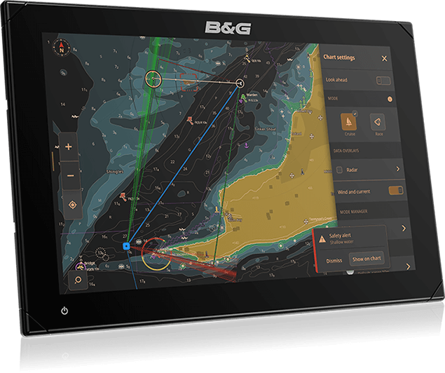
Navigation is clearer and more intuitive than ever before. With new tools, best-in-class Day and Night modes and improved Autorouting, you can always make the most of your time on the water.
Navigation is clearer and more intuitive than ever before. With new tools, best-in-class Day and Night modes and improved Autorouting, you can always make the most of your time on the water.
Makes navigation easy by giving you accurate, up-to-date vector chart detail derived from official sources, including hydrographic offices and survey data unique to C-MAP.
Makes navigation easy by giving you accurate, up-to-date vector chart detail derived from official sources, including hydrographic offices and survey data unique to C-MAP.
New modes, created to ensure maximum visibility and ease of use in all light and weather conditions. Always see the detail you need. Stay safe and navigate with ease.
New modes, created to ensure maximum visibility and ease of use in all light and weather conditions. Always see the detail you need. Stay safe and navigate with ease.
Integration with the B&G App. Enjoy the same chart experience on your Zeus® S, laptop, tablet and phone. Plan trips, review Tracks and plot Waypoints on your App and sync directly to your chartplotter, with no subscription fees required.
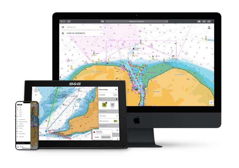
Integration with the B&G App. Enjoy the same chart experience on your Zeus® S, laptop, tablet and phone. Plan trips, review Tracks and plot Waypoints on your App and sync directly to your chartplotter, with no subscription fees required.
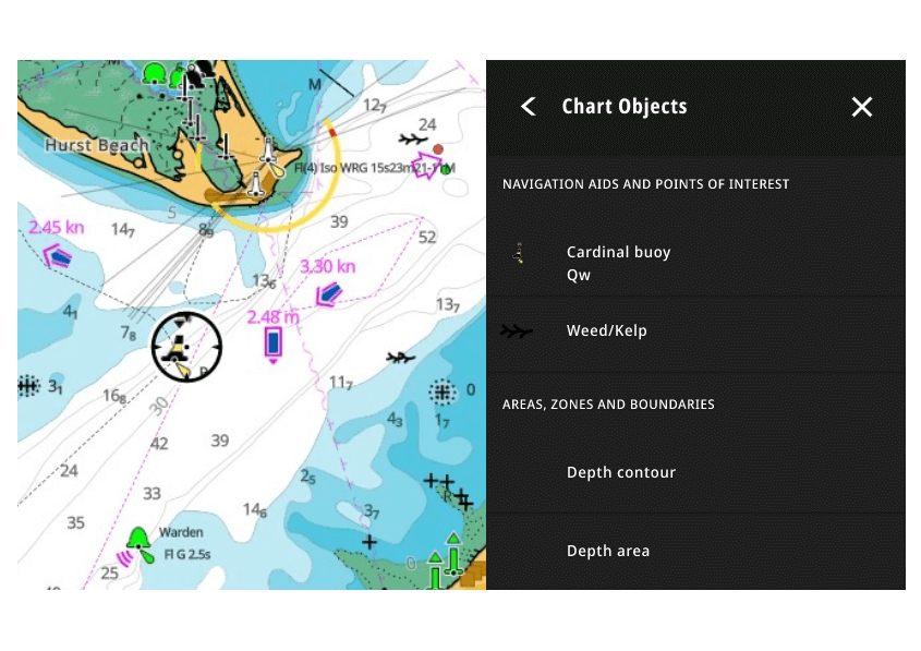
Quickly, intuitively see information on locations, POIs, tides, channels and more, with a simple touch of the screen.
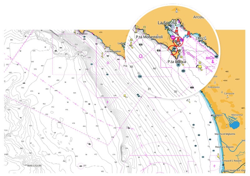
The new ENC Cartography option allows you to see a representation of the official chart created by the national hydrographic offices around the world*.
*Please be aware that chart cannot be used in an IMO approved ECDIS System and is not available in all locations.
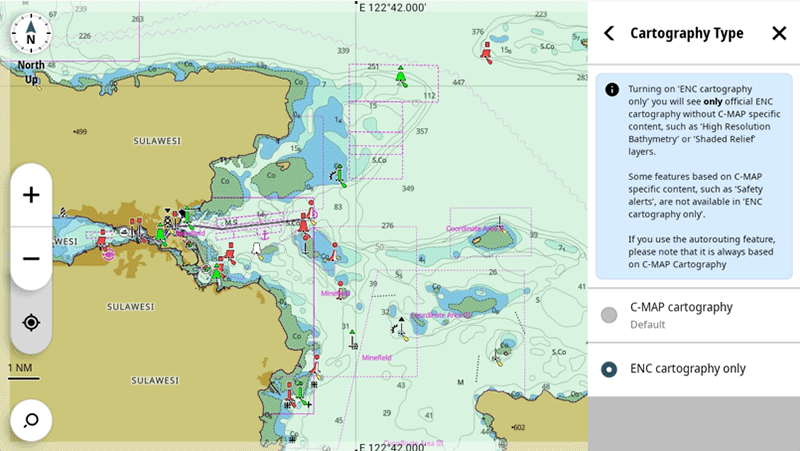
The new ENC Cartography option allows you to see a representation of the official chart created by the national hydrographic offices around the world*.
*Please be aware that charts cannot be used in an IMO approved ECDIS System and are not available in all locations.
Quickly, intuitively see information on locations, POIs, tides, channels and more, with a simple touch of the screen.
DISCOVER™ X |
|
|
Next Generation Charts |
|
|
New Map Inspector Tool |
|
|
Full-Featured Vector Charts |
|
|
Hi-Res Bathymetry |
|
|
Custom Depth Shading |
|
|
Best-In-Class Day & Night Modes |
|
|
Tides & Currents |
|
|
Detailed Marina Port Plans |
|
|
Harbor & Approach Details |
|
|
Subscription-Free Autorouting |
|
|
12 Months Free, Easy Updates |
|
| Connected Experience – Future-Proof | |
| ENC Cartography Option | |
REVEAL™ X |
|
|
Next Generation Charts |
|
|
New Map Inspector Tool |
|
|
Full-Featured Vector Charts |
|
|
Hi-Res Bathymetry |
|
|
Custom Depth Shading |
|
|
Best-in-class Day & Night Modes |
|
|
Tides & Currents |
|
|
Detailed Marina Port Plans |
|
|
Harbor & Approach Details |
|
|
Subscription-Free Autorouting |
|
|
12 Months Free, Easy Updates |
|
| Connected Experience – Future-Proof | |
| ENC Cartography Option | |
| Shaded Relief REVEAL Layer | |
| Satellite Imagery | |
| Vegetation Layer | |
| Border Hardness Layer | |
| Raster Charts | |
DISCOVER™ X |
|
|
Next Generation Charts |
|
|
New Map Inspector Tool |
|
|
Full-Featured Vector Charts |
|
|
Hi-Res Bathymetry |
|
|
Custom Depth Shading |
|
|
Best-In-Class Day & Night Modes |
|
|
Tides & Currents |
|
|
Detailed Marina Port Plans |
|
|
Harbor & Approach Details |
|
|
Subscription-Free Autorouting |
|
|
12 Months Free, Easy Updates |
|
| Connected Experience – Future-Proof | |
| ENC Cartoraphy Option | |
REVEAL™ X |
|
|
Next Generation Charts |
|
|
New Map Inspector Tool |
|
|
Full-Featured Vector Charts |
|
|
Hi-Res Bathymetry |
|
|
Custom Depth Shading |
|
|
Best-in-class Day & Night Modes |
|
|
Tides & Currents |
|
|
Detailed Marina Port Plans |
|
|
Harbor & Approach Details |
|
|
Subscription-Free Autorouting |
|
|
12 Months Free, Easy Updates |
|
|
Connected Experience – Future-Proof |
|
| ENC Cartography Option | |
| Shaded Relief REVEAL Layer | |
| Satellite Imagery | |
| Vegetation Layer | |
| Bottom Hardness Layer | |
| Raster Charts Layer | |


